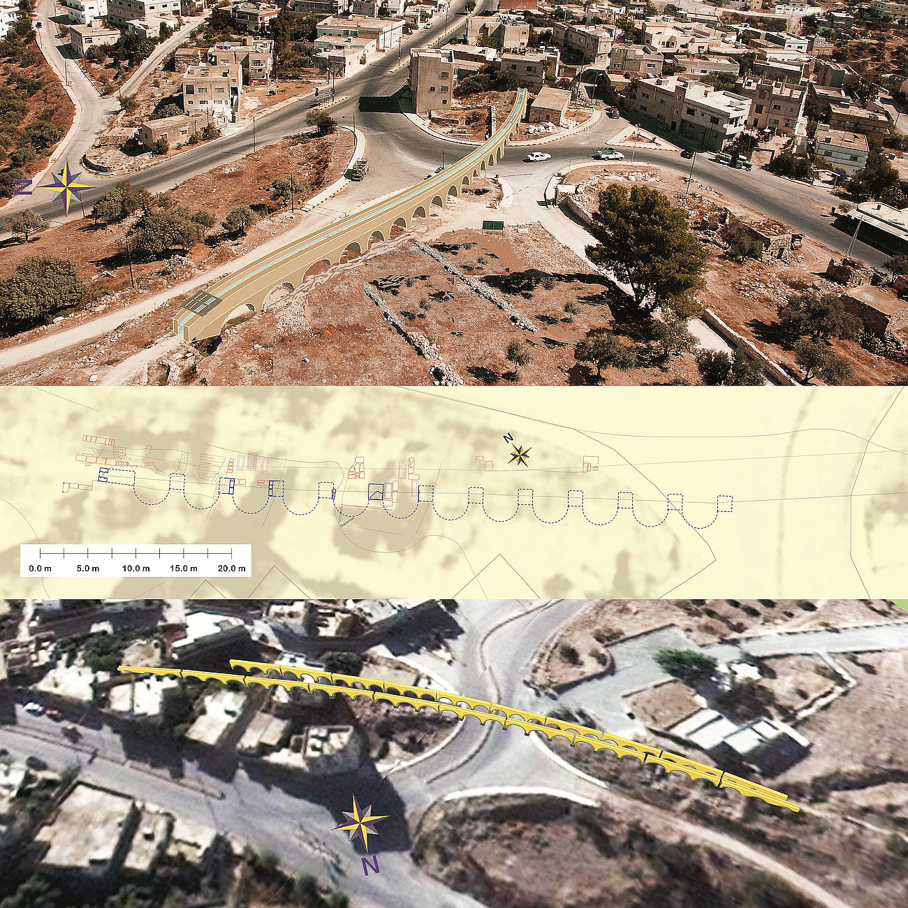
Until November 2009, only one aqueduct bridge was known.
In the summer months of 2009, in order to secure the new tourist building, an excavation was carried out by the Dept. of Antiquities. Here, right under the Ottoman house foundations, burial sites were excavated from the Hellenistic period. During a visit, I noted stone formations at the two edges of the excavation square, which were clearly the pillar foundations, up to the fighter, of a previously unknown bridge. The width and position of the pillars could be clearly related to more distant components, such as the sluice stones and other remains of foundations and abutments.
Undoubtly, it is a solitary built building, which was built before the hitherto known and by S. Kerner documented bridge; since the route of the newly found building runs closer to the city hill (southern course).
In this area, the two bridges have a lateral distance of 63 cm to each other. The clear separation is also visible in the area of the sluice stone which still lies in Situ. Here, the distance is only about 50cm to each other. Other differences between the two bridges are the clear widths, pillar heights, and coarser stone processing at the northern bridge. The southern bridge consisted of precisely carved limestone cuboids. With a vault thickness of 45cm and an average clear span of 3.68m. The limestone pier, 1.60m wide and in the longitudinal axis 1.50m, were built above a pedestral, which was constructed of basalt cuboids. There is an inner offset of 5 cm all-around between pedestral and pier. This new aqueduct bridge is identical in line with the sluice stone already described by S. Kerner. Thus, the long-discussed location problem next to the documented aqueduct clarifies itself. Due to the age, the measurements and the lines of both aqueduct bridges, it can be assumed that they also led different waters to Gadara. Note G. Schumacher, Northern Ajlun (1890) "Aquädukt entlang der römischen Straße“ and the two separate lines on the Gadara map.
While the southern aqueduct was able to carry the spring water of both Qanatsystems and then ended at the western abutment at the sluice stone lying in situ, the water of Schumacher’s channel system seems very plausible for the well-known northern aqueduct bridge. Especially since the cross section exposed by S.Kerner corresponds exactly with the dimensions given by G. Schumacher. The width of the Kerner aqueduct bridge of 3.20m mentioned in various literature and graphically drawn, is based either on transposed digits, or a misunderstanding; because, as the photos by S.Kerner himself unambiguously show and confirm the metrological evaluation, the real width of this bridge and thus also of the guided water canal is pretty accurate 2,38m. Here, not only the ratios of height and width of the double shell exactly match the specifications of G. Schumacher for the gutters along the road, but also the width of the flow channel is identical except for the semicircular brickwork.
 Lageplan und Visualisierungen der beiden Brücken
The length of the southern aqueduct bridge was about 148m, that of the northern bridge about 170 m.
The height at the entrance to the city system (position of the sluice stone) was 352.18 + 0.50m asl (positive step by Opus Cementicium) for the southern older bridge and about 352.00m asl for the exposed floating level of the northern Kerner aqueduct.
The width of the gutter at the sluice stone corresponds for the southern bridge, not only to G. Schumacher’s measurements documented on the Jisr el Mesari; but also corresponds to my calculation of the amount of water passing through the building. This calculation was confirmed by P. Keilholz using the calculation program Mike 11 and thus provides that this bridge was the real end of the Qanat Fir'aun’s long-distance water pipeline.
Conclusion: The newly discovered bridge can explain many of the previously unresolved problems, such as the exact guidance of the Qanat Fir'aun at the entrance of the Decapolis city Gadara, or the lateral offset of the sluice stone over the previously known bridge.
The southern aqueduct bridge, newly documented here, could have been used, even after increasing the amount of water, through modifications when the Qanat Fir'aun was put into operation.
It is particularly noteworthy that two complete or partially preserved bridge arches are hidden in the rubble of the slope. These aqueduct arches, together with those already described here, could give the most vivid and only aboveground remaining reference to the entire engineering achievement of the Qanat Firaun and thus, would be a new attraction in the archaeological ensemble of the decapolis city of Gadara.
About the distribution of water in Gadara, I refer to the publications of S.Kerner, O.Böser and especially P.Keilholz.
Get a small overview here.