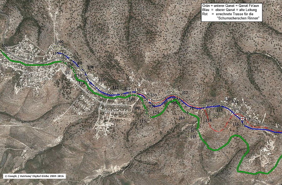
G. Schuhmacher and others described another water supply system. Those water channels are also known as Qanat Fir'aun. Undoubtly, those channels form an independent system, which was presumably built in the late 4th century.
Even if detailed descriptions exist, no archaeological indication could have been found since the 80's of the 20th century. The destruction, or reusing of building stones, might have already started a long time ago. This can be narrowed in terms of times, since G.A. Smith described that, between 1891 and 1900 and due to Gadara's resettlement, the place Umm Qeis had been grown enormous; at the expense of Gadara's old ruins which do not exist anymore - after 9 years.
Due to the reason that those evidences are not visible, the channel system, described by G. Schumacher, is disparaged to a road drainage; and the descriptions from the 19th century are derided as a phantasy.
Here again, G.A. Smith can help us, who adds two more facts about the third aqueduct which are highly relevant.
Inter alia, he describes that during those nine years almost all the visible relicts of the water pipe, between Umm Qeis and Ibdar, had been vanished. In my opinion, it is even more important that he states that the water pipe is also made out of basalt pipe elements.
"The basalt pipes of the conduit, which I saw in great numbers in 1891, have nearly all disappeared."

Thus, this complex street side system has nothing to do with road drainages. Without any detailed and specialist knowledge, it can be recognized that this system in terms of its construction and the dimensions of its water channel had never been served for a drainage.
Numerous examples of Roman streets or places show drainage channels but non of them can be compared to those dimensions. By omitting to regard the relations of those channels, a comparison of the cross section is misleading and not in accordance with the principles of any scientific research. The channel described by G. Schumacher is many times greater as those similar looking channels which are documented here in that picture or in the book "Wasser für die Dekapolis".

Let's address the solution which is proven scientifically:
- The channel system was next to the street (but not exactly parallel, see the picture above), along the southern watershed between Ibdar (500m asl) and Gadara (370m asl). According to G. Schumer, the system was 2,41m wide. (Steuernagel by other conversion 2,38m)
- Besides the channels which are described by G. Schumacher, G.A. Smith states that this system also included sections which were made out of basalt elements along the street. (among other things comparable with Gadara, or Hippos)
- Between el Qabu and Gadara, two identical channels ran in parallel. Therefore, the system's total width was 4,22m which is almost as wide as the Roman street.
- every channel had a width of over 81cm and was 31cm deep. Even with a minimal slope of 0,5 per mill and a freeboard of 5cm, the amount of ~ 50l/s water could had been carried through every of those channels. With a medial slope of 2%, which mostly correspond to the street gradient, the Q, which stands for the amount of water carried per time unit, would had been significantly higher. Undoubtedly, the amount of water had never been intended nor reached.
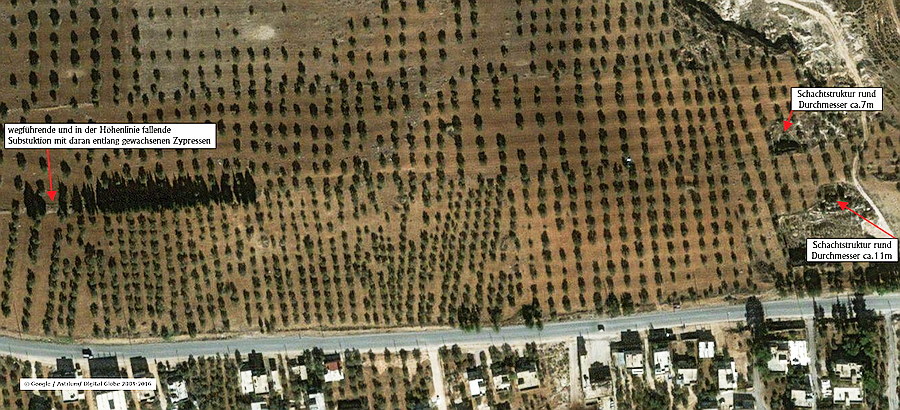
- Regarding the picture above and all the other description, the contour line of the third water system could have been calculated. Neither springs, reservoirs nor others could have been proven. But, southeastern from Ibdar, a stone quarry area is plot which might had been used originally as a water lifting system. By considering an older google-earth picture, I was able to document at least two circular ones, which have similar structures to a deep well. (see next picture) Such bucket chain - water lifting systems are driven by animals or human beings. They could produce between 1 and 5 l/s per system. Those lifting systems were verifiable proven in the Persian-Babylonian area and since the 3rd century by Philon of Byzanz. Generally, those systems are known and called as "Sakia".
Regarding the official Jordan maps M 1:25000, this area is called al Qantara, which would also indicate a vault or stony arch as with the Syrian Abu el Qantara in the course of Qanat Fir'aun. Further archaeological researches should prove this thesis in near future, whereby this area have been extensively used and overbuilt by locals since 2014.
 Gebiet "al Qantara" Beginn des 3. Wassersystems auf H= 496m asl
- Certainly, the expected amount of water of max. 20 l/ s about the Qanat Fir'aun aqueduct pipe was a significant restriction. The building construction of this water supply system is not usual. At that time it was classified that the pipe system and the water transported were sufficient for the needs of Gadara's inhabitants.
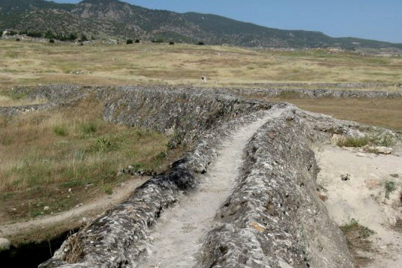
- Comparable pipe- aqueduct systems exist, even if they were built with a very simple construction. Hierapolis / Pammukale can be mentioned as an example.


- Eastern of today's village entrance of Umm Qeis, a heavy sinter inflow from above into one of the access shafts of the above qanat systems can be proven ( where did the water come from, if not coming out of the pipe system?). Regarding the thickness of the fusion, considerable amounts of water must have passed the functioning part of the qanat system for a long time.
- To the north, the so called "Kerner Bridge" in Gadara is the logical continuation of Schumacher's pipe system. On the one hand, the building construction and the relatively coarse material is not identical with the older bridge, which was found in 2009 by the author. On the other hand, the deviating pier positions of the northern construction also indicates a the construction age, after the destruction of the older bridge.
- At the end, the located profile and the stones from the sidewall, which still lie in Situ, correspond exactly to the dimensions of G. Schumachers presentation in "Northern Ajlun". Destructions in this area explain why the separate round stonewalled channel profile at the end of the construction does not exist anymore.
Additionally, waterproof mortar documented in S. Kerner's presentation could not be proven. The real width of the "Kernersche Bridge" with 2,38m exactly corresponds to the data given by G. Schumacher. Therefore, the last two (inboard) remaining stones of that sidewall of that bridge are sadly the one and only relicts of the described aqueduct channels. - Due to missing evidence, no reliable statement about the usage of the arriving water at the mentioned bridge can be made.
Why was a second channel starting in El Qabu necessary?
First of all, a discharge of eventually resulting surface water from the higher located hilly terrain, northern to the street at el Qabu, can not be excluded. Still, this seems only partially plausible.
Rather , the generally lower gradient in this area was taken into account, which at least could have led temporarily to an overflow of only one existing channel. Additionally, smaller and different heights or additional water intakes could have been realized and dispensed by two channels. This aqueduct also ran towards Gadara. Further information about the bridges immediately before Gadara can be found here.